TypeScript Deck.GL
Introduction TODO#
See also TypeScript-PHP page which discusses the development of the backend in PHP and frontend in TypeScript, to be able use the techologies listed here.
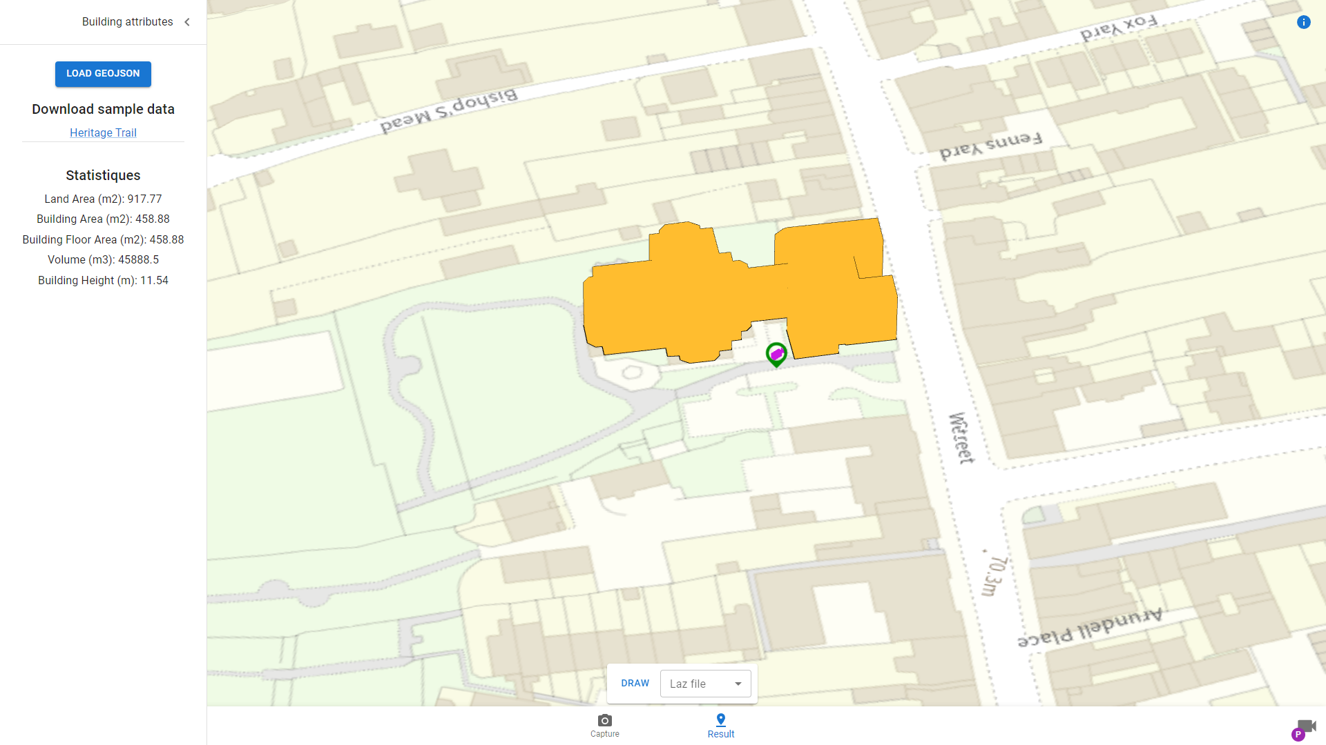
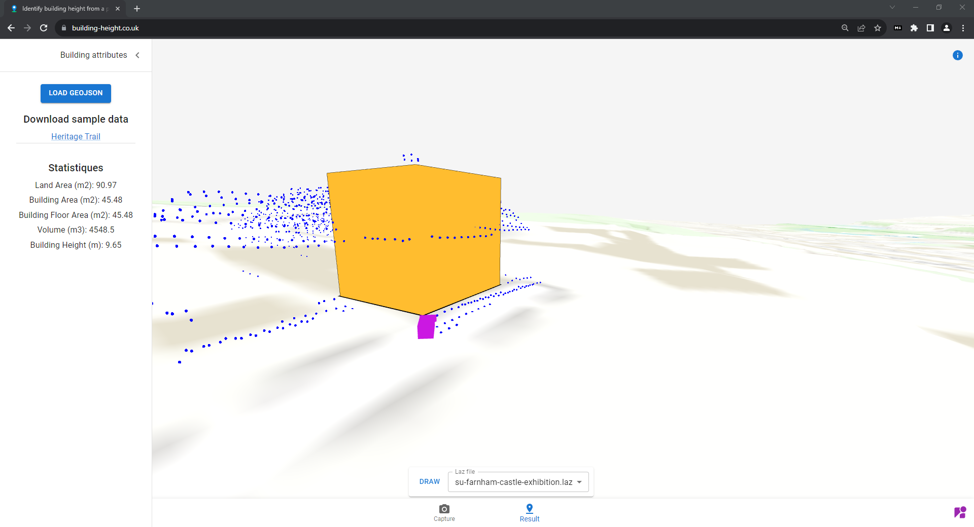
Identify building height from a photo Building-Height is a system that can determine the attributes of historical buildings in England. The building part can be defined just by uploading a photo.
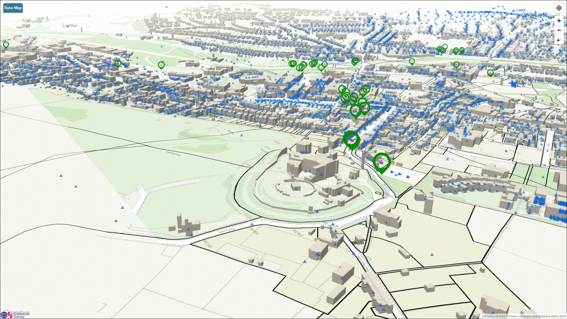
Working with geo datasets and image metadata to visualize 3d buildings showing building attributes, such as heights, volumes.
- building layer polygon extrusion depicts the 3D building
- creates 2 geojson layers (using deck.gl)
- building height attribute from ordnance survey
- polygon of building footprints from ordnance survey
- lidar data from environment agency for 3d terrain
- creates a 3D building on a map canvas (using mapbox-gl) after taking a geojson file as input.
The goal is to create a terrain map of southeast England using point cloud datasets (appendix a) where building polygons will be extruded on a map with real world coordinates.
Point Cloud#
Upload an image#
You can upload or capture from your camera with active GPS
Image metadata will be displayed#
Extracted metadata from the image you uploaded will be displayed
Building height will be identified#
The building height, map location of the building and its attributes will be displayed
3D Navigation#
- Pan Mouse Left
- Rotate Mouse Right
- Shift + Mouse Left
- Top-down Camera T
- Perspective Camera P
- Driver Camera D
- Recenter Camera R

Showcase#
Create a link to a showcase which contains exif data extracted from photos collected in mappics galleries via api.
- New button Showcase
- Function fetch all exif data via api from images for a particular gallery (first one heritage-trail-Farnham) this will be a stream as shown in streetscape.gl
- Fetch all polygons via api (already works)
- Exclude all buildings (already works for 1no. building)
curl -X 'GET' \
  'https://api.buildingshistory.co.uk/api/v1/images/?gallery_id=985e3f6d-09f1-4a0f-8cbf-060514ecb860' \
  -H 'accept: application/json' \
  -H 'X-CSRF-TOKEN:
Gallery#
buildingshistory gallery (current)
TODO#
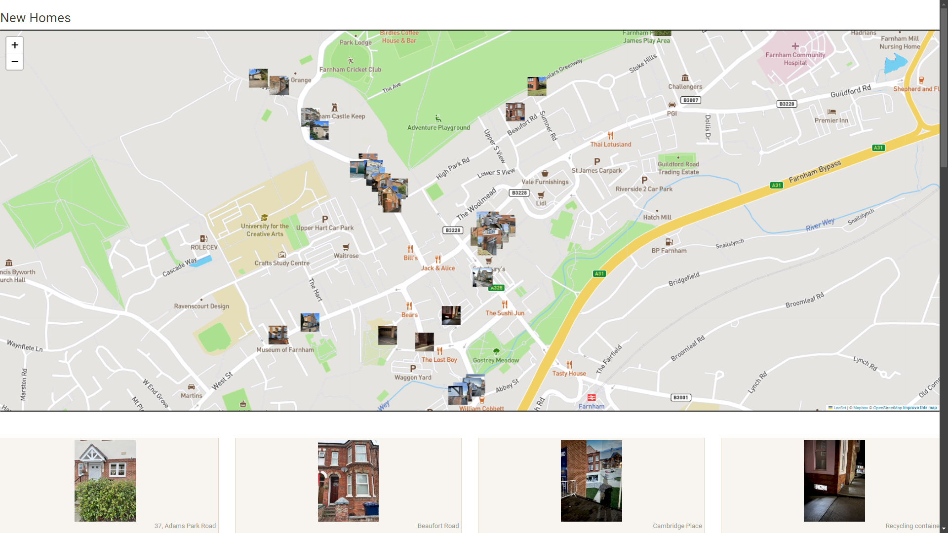
https://buildingshistory.co.uk/galleries/new-homes/
Creating a terrain map#
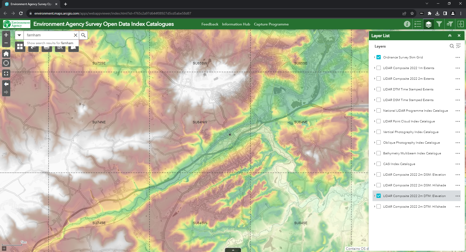
Go Enviroment Agency website, which contains Lidar data for the United Kingdom.
Search for the area in which you would like to create the terrain map, below show a results for Farnham in Surrey
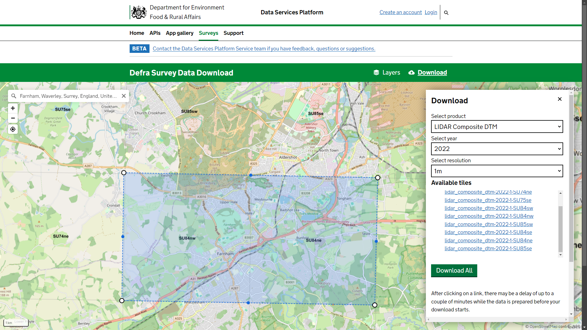
Available tiles used in this project
- lidar_composite_dtm-2022-1-SU84nw
- lidar_composite_dtm-2022-1-SU84ne
The surface (basemap) terrain would be covered by ordnance survey tiles, field of view (FOV) would be from street view showing camera and building with real coordinates.
(figure1)
Buildingshistory.co.uk shows concept but not using real world coordinates, has a terrain and basemap.
(figure2).
create a rgb Mbtile (PNG)#
for our tileserver of SU84NW to either geoserver to tilesserver-g with Arcgis
 (figure 3)
Deck-GL#
cameraGPSData#
(GPSImgDirection) to position initialViewState -20m behind, show if a person was taking photo of building
    const exif3dCameraLayer = new ScenegraphLayer({
      id: "exif3d-camera-layer",
      data: cameraGPSData,
      scenegraph: url,
      getPosition: (d) => d.coordinates,
      getColor: (d) => [203, 24, 226],
      getOrientation: (d) => [0, -d.bearing, 90],
      opacity: 1,
    });
hover over#
pink camera shows image hoverover from building-height.co.uk

draw lidar#
(figure 1)
API/ Database#
- geojson for map of 1 building
- building height and toid
3. Would like to add post this geojson into su_building table
            "properties": {
                "RelHMax": 13.1,
                "TOID": "osgb1000014525478",
                "_symbol": 4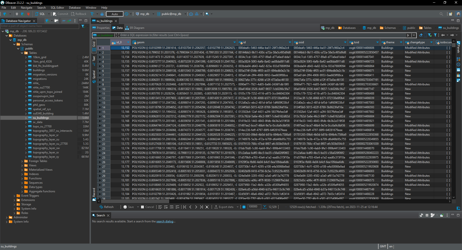
Geoserver#
cache OS tiles#
What to use cached tiles from geoserver Replace https://api.os.uk/maps/raster/v1/zxy/Outdoor_3857/{z}/{x}/{y}.png?key=wXtior9ubP6EFLYP5l6isfWZYiKqOlf7
Can you configure geoserver to work {z}/{x}/{y}.png, started to set it up on geoserver this morning. Followed https://blog.ianturton.com/2021/07/22/Cascading-OS-Map-Tiles.html
TerrainLayer (deck.gl)#
https://deck.gl/docs/api-reference/geo-layers/terrain-layer
import {TerrainLayerDemo} from '@site/src/doc-demos/geo-layers';
The TerrainLayer reconstructs mesh surfaces from height map images, e.g. Mapzen Terrain Tiles, which encodes elevation into R,G,B values.
When elevationData is supplied with a URL template, i.e. a string containing '{x}' and '{y}', it loads terrain tiles on demand using a TileLayer and renders a mesh for each tile. If elevationData is an absolute URL, a single mesh is used, and the bounds prop is required to position it into the world space.
import Tabs from '@theme/Tabs'; import TabItem from '@theme/TabItem';
import {Deck} from '@deck.gl/core';
import {TerrainLayer} from '@deck.gl/geo-layers';

const layer = new TerrainLayer({
  elevationDecoder: {
    rScaler: 2,
    gScaler: 0,
    bScaler: 0,
    offset: 0
  },
  // Digital elevation model from https://www.usgs.gov/
  elevationData: 'https://raw.githubusercontent.com/visgl/deck.gl-data/master/website/terrain.png',
  texture: 'https://raw.githubusercontent.com/visgl/deck.gl-data/master/website/terrain-mask.png',
  bounds: [-122.5233, 37.6493, -122.3566, 37.8159],
});

new Deck({
  initialViewState: {
    longitude: -122.4,
    latitude: 37.74,
    zoom: 11
  },
  controller: true,
  layers: [layer]
});
import React from 'react';
import DeckGL from '@deck.gl/react';
import {TerrainLayer} from '@deck.gl/geo-layers';

function App() {
  const layer = new TerrainLayer({
    elevationDecoder: {
      rScaler: 2,
      gScaler: 0,
      bScaler: 0,
      offset: 0
    },
    // Digital elevation model from https://www.usgs.gov/
    elevationData: 'https://raw.githubusercontent.com/visgl/deck.gl-data/master/website/terrain.png',
    texture: 'https://raw.githubusercontent.com/visgl/deck.gl-data/master/website/terrain-mask.png',
    bounds: [-122.5233, 37.6493, -122.3566, 37.8159],
  });

  return <DeckGL
    initialViewState={{
      longitude: -122.4,
      latitude: 37.74,
      zoom: 11
    }}
    controller
    layers={[layer]}
  />;
}
Installation#
To install the dependencies from NPM:
npm install deck.gl
# or
npm install @deck.gl/core @deck.gl/mesh-layers @deck.gl/geo-layers
import {TerrainLayer} from '@deck.gl/geo-layers';
import type {TerrainLayerProps} from '@deck.gl/geo-layers';

new TerrainLayer(...props: TerrainLayerProps[]);
To use pre-bundled scripts:
<script src="https://unpkg.com/deck.gl@^9.0.0/dist.min.js"></script>
<!-- or -->
<script src="https://unpkg.com/@deck.gl/core@^9.0.0/dist.min.js"></script>
<script src="https://unpkg.com/@deck.gl/mesh-layers@^9.0.0/dist.min.js"></script>
<script src="https://unpkg.com/@deck.gl/geo-layers@^9.0.0/dist.min.js"></script>
new deck.TerrainLayer({});
Properties#
When in Tiled Mode, inherits from all TileLayer properties. Forwards wireframe property to SimpleMeshLayer.
Data Options#
elevationData (string | string[], required) {#elevationdata}
Image URL that encodes height data.
- If the value is a valid URL, this layer will render a single mesh.
- If the value is a string, and contains substrings
{x}and{y}, it is considered a URL template. This layer will render aTileLayerof meshes.{x}{y}and{z}will be replaced with a tile's actual index when it is requested. - If the value is an array: multiple URL templates. See
TileLayer'sdataprop documentation for use cases.
texture (string | null, optional) {#texture}
Image URL to use as the surface texture. Same schema as elevationData.
- Default:
null
meshMaxError (number, optional) {#meshmaxerror}
Martini error tolerance in meters, smaller number results in more detailed mesh..
- Default:
4.0
elevationDecoder (object, optional) {#elevationdecoder}
Parameters used to convert a pixel to elevation in meters. An object containing the following fields:
rScaler: Multiplier of the red channel.gScaler: Multiplier of the green channel.bScaler: Multiplier of the blue channel.offset: Translation of the sum.
Each color channel (r, g, and b) is a number between [0, 255].
For example, the Mapbox terrain service's elevation is encoded as follows:
height = -10000 + ((R * 256 * 256 + G * 256 + B) * 0.1)
The corresponding elevationDecoder is:
{
  "rScaler": 6553.6,
  "gScaler": 25.6,
  "bScaler": 0.1,
  "offset": -10000
}
The default value of elevationDecoder decodes a grayscale image:
{
  "rScaler": 1,
  "gScaler": 0,
  "bScaler": 0,
  "offset": 0
}
bounds (number[4], optional) {#bounds}
Bounds of the image to fit x,y coordinates into. In [left, bottom, right, top].
left and right refers to the world longitude/x at the corresponding side of the image.
top and bottom refers to the world latitude/y at the corresponding side of the image.
Must be supplied when using non-tiled elevation data.
- Default:
null
loadOptions (object, optional)#
On top of the default options, also accepts options for the following loaders:
- TerrainLoader
- ImageLoader if the
textureprop is supplied
Note that by default, the TerrainLoader parses data using web workers, with code loaded from a CDN. To change this behavior, see loaders and workers.
Render Options#
color (Color, optional)#
Color to use if texture is unavailable. Forwarded to SimpleMeshLayer's getColor prop.
- Default:
[255, 255, 255]
wireframe (boolean, optional)#
Forwarded to SimpleMeshLayer's wireframe prop.
- Default:
false
material (Material, optional)#
Forwarded to SimpleMeshLayer's material prop.
- Default:
true
Sub Layers#
The TerrainLayer renders the following sublayers:
tiles- a TileLayer. Only rendered ifelevationDatais a URL template.mesh- a SimpleMeshLayer rendering the terrain mesh.
Source
modules/geo-layers/src/terrain-layer
TerrainLoader (deck.gl)#
The TerrainLoader reconstructs mesh surfaces from height map images, e.g. Mapzen Terrain Tiles, which encodes elevation into R,G,B values.
| Loader | Characteristic |
|---|---|
| File Extension | .png, .pngraw |
| File Type | Binary |
| File Format | Encoded height map |
| Data Format | Mesh |
| Supported APIs | load, parse |
| Decoder Type | Asynchronous |
| Worker Thread Support | Yes |
| Streaming Support | No |
Usage#
import {ImageLoader} from '@loaders.gl/images';
import {TerrainLoader} from '@loaders.gl/terrain';
import {load, registerLoaders} from '@loaders.gl/core';

registerLoaders(ImageLoader);

const data = await load(url, TerrainLoader, options);
Options#
| Option | Type | Default | Description |
|---|---|---|---|
terrain.meshMaxError |
number |
10 |
Mesh error in meters. The output mesh is in higher resolution (more vertices) if the error is smaller. |
terrain.bounds |
array<number> |
null |
Bounds of the image to fit x,y coordinates into. In [minX, minY, maxX, maxY]. If not supplied, x and y are in pixels relative to the image. |
terrain.elevationDecoder |
object |
See below | See below |
terrain.tesselator |
string |
auto |
See below |
terrain.skirtHeight |
number |
null |
If set, create the skirt for the tile with particular height in meters |
elevationDecoder#
Parameters used to convert a pixel to elevation in meters. An object containing the following fields:
rScale: Multiplier of the red channel.gScale: Multiplier of the green channel.bScale: Multiplier of the blue channel.offset: Translation of the sum.
Each color channel (r, g, and b) is a number between [0, 255].
For example, the Mapbox terrain service's elevation is encoded as follows:
height = -10000 + ((R * 256 * 256 + G * 256 + B) * 0.1)
The corresponding elevationDecoder is:
{
  "rScale": 6553.6,
  "gScale": 25.6,
  "bScale": 0.1,
  "offset": -10000
}
The default value of elevationDecoder decodes a grayscale image:
{
  "rScale": 1,
  "gScale": 0,
  "gScale": 0,
  "offset": 0
}
tesselator#
The choices for tesselator are as follows:
auto:
- Chooses Martini if possible (if the image is a square where both height and width are powers of 2), otherwise uses Delatin instead, which has no input image limitations.
martini:
- Uses the Martini algorithm for constructing a mesh.
- Only works on square 2^n+1 x 2^n+1 grids.
- Generates a hierarchy of meshes (pick arbitrary detail after a single run)
- Optimized for meshing speed rather than quality.
delatin:
- Uses the Delatin algorithm for constructing a mesh.
- Works on arbitrary raster grids.
- Generates a single mesh for a particular detail.
- Optimized for quality (as little triangles as possible for a given error).
Types of Mapzen Terrain Tiles#
Mapzen Terrain Tiles provide worldwide basemap coverage sourced from SRTM and other open data projects with several different data formats and varying levels of processing.
The following formats are available, with full details below:
terrariumwith extensionpngin Web Mercator projection, 256x256, 260x260, 512x512, and 516x516 tilesnormalwith extensionpngin Web Mercator projection, 256x256, 260x260, 512x512, and 516x516 tilesgeotiffwith extensiontifin Web Mercator projection, 512x512 tilesskadiwith extensionhgtin unprojected latlng, 1°x1° tiles
Need help displaying raster tiles in a map? We have several examples using Mapzen raster tiles to style in your favorite graphics library including Tangram.
Terrarium#
Terrarium format PNG tiles contain raw elevation data in meters, in Web Mercator projection (EPSG:3857). All values are positive with a 32,768 offset, split into the red, green, and blue channels, with 16 bits of integer and 8 bits of fraction.
In other words, the red channel encodes the "256s" place, the green channel the "1s" place, and the blue channel the fractional component, which is 0 - 0.99609375 (255/256) in increments of 0.00390625 (1 / 256).
To decode:
(red * 256 + green + blue / 256) - 32768
To encode, asuming a starting value of v:
v += 32768
r = floor(v/256)
g = floor(v % 256)
b = floor((v - floor(v)) * 256)
For example, with a starting value of 2523.266:
v += 32768
> 35291.266
r = floor(v/256)
> 137
g = floor(v % 256)
> 219
b = floor((v - floor(v)) * 256)
> 68

> rgb(137, 219, 68)
Decoded, this gives us:
(r * 256 + g + b / 256) - 32768
> 2523.265625
The range of the elevation data (-11000 - 8900 meters) spans rgb(85, 8, 0) - rgb(162, 198, 0), or [0.33203125, 0.03125, 0] - [0.6328125, 0.7734375, 0].
Normal#
Normal format PNG tiles are processed elevation data with the the red, green, and blue values corresponding to the direction the pixel “surface” is facing (its XYZ vector), in Web Mercator projection (EPSG:3857). The alpha channel contains quantized elevation data with values suitable for common hypsometric tint ranges.
red= x vectorgreen= y vectorblue= z vectoralpha= quantized elevation data
High alpha channel values indicate lower elevation values (below sea level), making them more opaque. Specifically, normal format alpha values are counted in (floored) elevation increments. Below sea level they start at -11,000 meters (Mariana Trench) and range to -1,000 meters in 1,000 meter increments, with more detail on the coastal shelf at -100, -50, -20, -10 and -1 meters and finally 0 (intertidal zone). Values above sea level are reported in 20 meter increments to 3,000 meters, then 50 meter increments until 6,000 meters, and then 100 meter increments until 8,900 meters (Mount Everest).
Encoding quantized height ranges (src):
for i in range(0, 11):
    table.append(-11000 + i * 1000)
table.append(-100)
table.append( -50)
table.append( -20)
table.append( -10)
table.append(  -1)
for i in range(0, 150):
    table.append(20 * i)
for i in range(0, 60):
    table.append(3000 + 50 * i)
for i in range(0, 29):
    table.append(6000 + 100 * i)
To decode quantized height value:
255 - bisect.bisect_left(HEIGHT_TABLE, h)
References#
Terrain#
- https://houseprices.io/lab/lidar/map – Easily the best way to view Lidar. Only works on Chrome tho. Based on the 1m DSM data. Actually better than anything I got from this!
- https://deck.gl/docs/api-reference/geo-layers/terrain-layer
- https://github.com/tilezen/joerd/blob/master/docs/formats.md#terrarium terrarium with extension png in Web Mercator projection, 256x256, 260x260, 512x512, and 516x516 tiles
- https://environment.maps.arcgis.com/home/user.html?user=ea.geomatics.admin
Deck-GL#
Technology Stack#
- React-mapgl
- Exif-extractor
- Mapboxgl
- Deckgl
- PolygonLayer (buildings)
- IconLayer (camera)
- GeoJsonLayer
- ScenegraphLayer
- OrbitController